
29Jul
How Ocean Waves Shape Coastal Landscapes
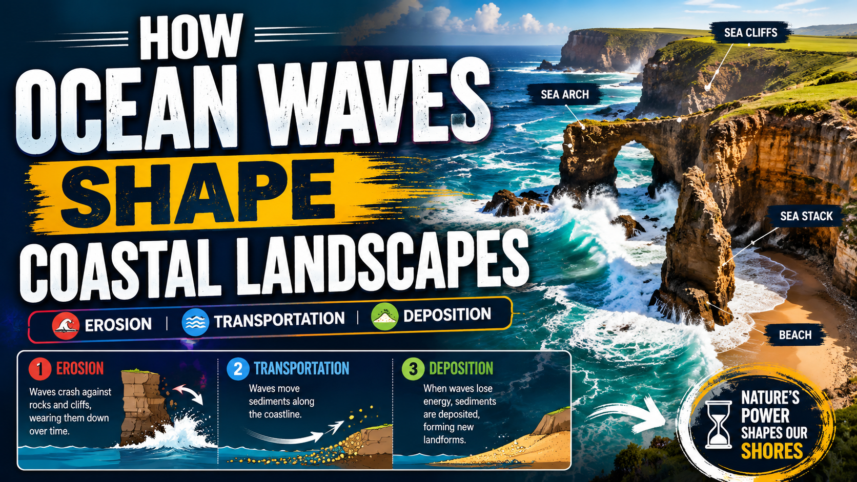
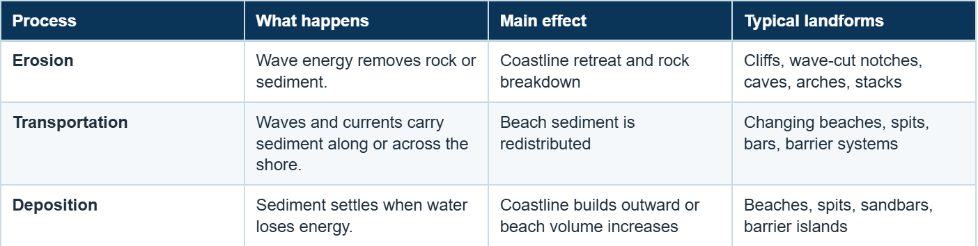
Ocean waves shape coastal landscapes through three major processes: erosion, transportation, and deposition. They can cut cliffs and caves into exposed rock, carry sediment along the shore, and build beaches, spits, sandbars, and barrier islands where wave energy decreases.

Every coastline tells a different story of wave energy, rock strength, and sediment movement. A storm exposed rocky shore may retreat as its cliff base is repeatedly attacked, while a nearby sheltered bay may gradually collect sand and widen. Because waves can both remove and rebuild coastal material, the shoreline is not a fixed boundary. It is a constantly adjusting zone between land and sea.
Understanding how waves change coastlines helps explain why some beaches shrink after storms, why caves and arches appear in rocky headlands, and why sediment may accumulate kilometers away from the place where it was first eroded.
The Three Ocean Wave Processes That Shape Coasts
Coastal Erosion Caused by Waves
Coastal erosion begins when waves transfer energy to rock, cliffs, beaches, and loose sediment. The rate of change varies widely: a single storm can remove a large volume of beach sand in hours, while the development of a cliff, cave, or stack may take many years or centuries.
Hydraulic Action
Hydraulic action occurs when breaking waves force water and compressed air into joints and cracks. Repeated pressure widens weak points until fragments break away. It is especially effective on exposed coasts where high energy waves strike the same rock face again and again.
Abrasion
Abrasion happens when waves throw sand, pebbles, and rock fragments against the shore. The sediment acts like a natural grinding tool, scraping and wearing down cliff bases, platforms, and rocky surfaces.
Attrition
Attrition affects the sediment carried by waves. Pebbles and rock fragments collide, break into smaller pieces, and become smoother and more rounded. Over time, some of this material contributes to beach sand and finer coastal sediment.
Solution and Chemical Weathering
Some coastal rocks contain minerals that are vulnerable to seawater and chemical weathering. Dissolution can weaken these materials and make mechanical erosion more effective, although the importance of this process depends on local geology and water chemistry.
Why erosion is uneven
Waves do not cut every part of a coast at the same rate. Hard and soft rock layers, cracks, faults, headlands, bays, sediment cover, and wave direction create zones of stronger and weaker erosion.
Longshore Drift Explained: How Waves Move Sediment
Waves often approach a beach at an angle. The swash carries sediment diagonally up the beach, while gravity pulls the backwash more directly downslope. Repeated wave action produces a zigzag movement of sand and gravel along the shoreline. This process is known as longshore drift.
Longshore currents and drift can move sediment away from one beach and supply another. As a result, one stretch of coast may narrow while a down current area gains sand. Jetties, groynes, harbors, and seawalls can interrupt this movement, sometimes protecting one location while reducing sediment farther along the coast.
Coastal Landforms Created by Wave Erosion
Rocky coastlines often develop a recognizable sequence of features as waves exploit weak points in headlands. The sequence is not identical everywhere, but the following landforms show how repeated erosion can transform resistant coastal rock.
Sea Cliffs
Waves cut into the base of a slope and may create a wave-cut notch. When the unsupported rock above collapses, the cliff face retreats inland. Repeated collapse can leave a gently sloping rock surface known as a wave-cut platform.
Sea Caves
Cracks, joints, or softer rock layers widen as hydraulic action and abrasion remove material. Continued erosion can enlarge the opening into a sea cave.
Sea Arches
A cave may eventually cut through a headland or connect with another opening, creating a natural arch. The arch remains temporary because waves and weathering continue to weaken the roof.
Sea Stacks and Stumps
When an arch roof collapses, an isolated pillar called a sea stack may remain offshore. Continued erosion can reduce the stack to a lower stump, sometimes visible mainly at low tide.
How Waves Build Beaches and Depositional Landforms
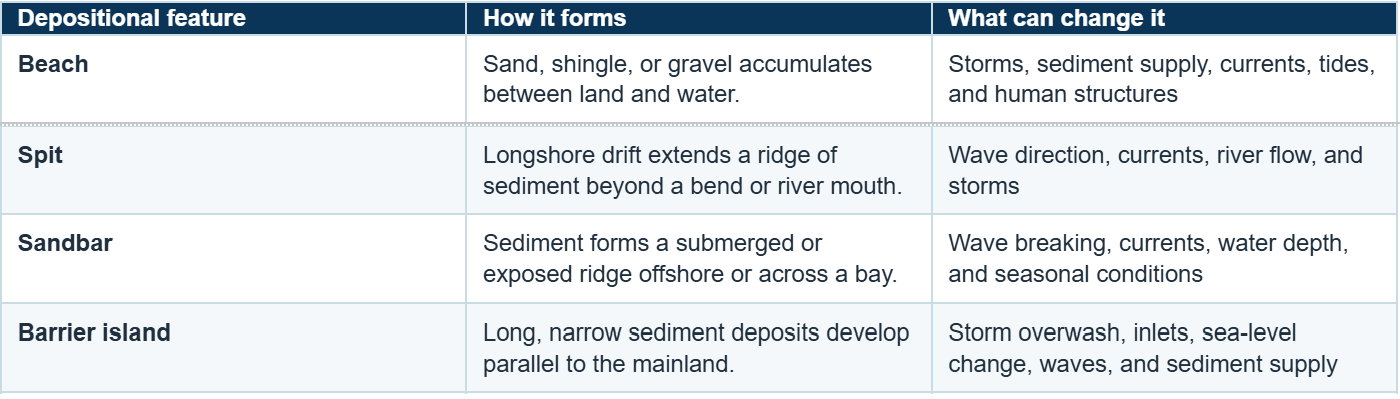
Deposition occurs when waves and currents lose enough energy that they can no longer carry the same sediment load. Sheltered water, gentle beach slopes, and an available sediment supply encourage accumulation. The balance between sediment arriving and sediment leaving determines whether a beach grows, narrows, or shifts position.
Real-World Examples of Wave-Shaped Coastlines
Named examples make coastal processes easier to recognize because they show how wave energy and geology work together in different settings.
The Twelve Apostles, Australia
Along Victoria's Port Campbell coast, high energy Southern Ocean waves have helped isolate limestone cliffs into caves, arches, islands, and tall offshore stacks. The surviving formations are remnants of a coastline that continues to change.
Hōlei Sea Arch, Hawaiʻi
At Hawaiʻi Volcanoes National Park, wave erosion has cut a sea arch into volcanic coastal rock. The site illustrates that arches are temporary: continued erosion can eventually collapse the roof and leave a stack or rubble.
The White Cliffs of Dover, England
The chalk cliffs show how rock type, fractures, wave exposure, weathering, and coastal defenses interact. Where human structures reduce wave attack, the cliff surface can behave differently from exposed sections.
Factors That Control How Quickly a Coastline Changes
- Wave energy and storms: Large waves and storm surge can move enormous volumes of sediment, cut dunes, damage cliffs, and produce sudden shoreline change.
- Rock type and structure: Harder rock usually resists erosion longer than weaker material, but joints, bedding planes, faults, and fractures may create vulnerable pathways.
- Coastal shape: Wave refraction can concentrate energy on headlands, while bays and sheltered coves often receive calmer water and more deposition.
- Sediment supply: A beach can persist only when enough sand or gravel enters the system to replace material removed by waves and currents.
- Tides and currents: Water level controls where waves break, while currents transport sediment along and away from the shore.
- Sea level: Higher water levels allow waves to act farther inland and can increase pressure on dunes, cliffs, wetlands, and low-lying shorelines.
- Human activity: Dams, dredging, sand mining, ports, seawalls, jetties, and beach nourishment can alter sediment movement and wave conditions.
How Climate Change Affects Wave-Shaped Coastlines
Climate change does not create every case of coastal erosion, but it can change the conditions under which waves reach the shore. Rising sea levels allow wave energy and storm water to act at higher elevations and farther inland. In some regions, changing storm patterns, rainfall, wind, and sediment supply may also influence erosion, flooding, overwash, and shoreline migration.
The response is not uniform. A sandy barrier island, a rocky cliff, a mangrove-fringed coast, and an engineered waterfront will react differently. Scientists therefore combine local measurements with regional models rather than applying one prediction to every coast.
How Scientists Measure Changing Coastlines
Coastal change can be gradual, seasonal, or sudden. To separate short-term storm effects from long term trends, scientists compare observations collected across different timescales.
- Field surveys: GPS profiles, sediment samples, cliff measurements, and repeated beach cross-sections document conditions on the ground.
- Aerial and satellite imagery: Images reveal shoreline position, beach width, dune damage, inlet migration, and landform change over large areas.
- LiDAR and elevation mapping: Laser based elevation data can measure changes in dunes, cliffs, and beaches in three dimensions.
- Wave and water level monitoring: Buoys, tide gauges, and nearshore instruments connect shoreline change with waves, tides, currents, and storms.
- Numerical models: Models test how sediment and shorelines may respond to storms, sea-level scenarios, and different management choices.
Why Understanding Coastal Change Matters
Studying wave shaped landscapes helps communities make better decisions about coastal protection, tourism planning, habitat conservation, and climate adaptation. Understanding how beaches, dunes, cliffs, and wetlands respond to wave energy can help identify places at greater risk of erosion, overwash, or flooding.
Coastal science supports decisions about:
- protecting people, roads, homes, and critical infrastructure;
- maintaining beaches and public access;
- restoring dunes, wetlands, reefs, and other natural buffers;
- planning development away from rapidly changing shorelines;
- managing ports, jetties, seawalls, and nourishment projects;
- protecting habitats and culturally important coastal sites.
Coastlines cannot be frozen permanently in one position. Effective management begins by understanding the processes already moving sediment and reshaping the shore.
Conclusion
Ocean waves reshape coastal landscapes by eroding rock, transporting sediment, and depositing material in lower-energy settings. These linked processes produce cliffs, caves, arches, stacks, beaches, spits, sandbars, and barrier islands, while continually changing the position and character of the shoreline.
The pace of change depends on more than wave action alone. Geology, sediment supply, storms, tides, currents, sea level, coastal shape, and human decisions all influence the result. Reading a coastline therefore means looking at the whole system, where energy is concentrated, where sediment comes from, where it moves, and where it settles.
Explore more ocean and Earth science topics. Visit Oceanography
Frequently Asked Questions About Coastal Wave Processes
1. How do ocean waves shape coastal landscapes?
Answer: Ocean waves shape coastal landscapes through erosion, transportation, and deposition. They remove rock and sediment, move material along and across the shore, and deposit it to form features such as beaches, spits, sandbars, cliffs, caves, arches, and stacks.
2. What is coastal erosion caused by waves?
Answer: Coastal erosion is the removal of shoreline rock or sediment by wave energy. Hydraulic action, abrasion, attrition, chemical weathering, currents, and storm-driven water levels can all contribute.
6. Where can I learn more about coastal processes?
Answer: The National Oceanic and Atmospheric Administration ocean resources provide educational information about oceans, coastal environments, and marine processes.
3. Do waves only destroy coastlines?
Answer: No. Waves both erode and build coastlines. They may cut material from one area, transport it alongshore, and deposit it elsewhere where the water has less energy.
4. What is longshore drift?
Answer: Longshore drift is the sideways movement of beach sediment caused by waves approaching the shoreline at an angle. Swash pushes material diagonally up the beach, and backwash moves it downslope, creating a zigzag transport path along the coast.
5. What are examples of wave erosion landforms?
Answer: Common examples include sea cliffs, wave cut notches, platforms, sea caves, sea arches, stacks, and stumps. Their development depends on rock structure, wave exposure, and time.
6. How long does coastal erosion take?
Answer: The timescale ranges from hours to centuries. A major storm can remove beach sediment in a single event, while the formation and retreat of cliffs, arches, and stacks usually require repeated erosion over much longer periods.
7. Why are some beaches disappearing?
Answer: A beach narrows when sediment leaves faster than it is replaced. Storms, interrupted longshore drift, reduced river sediment, sea level rise, dredging, coastal structures, and changes in currents can all affect the balance.
8. How does rock type affect coastal erosion?
Answer: Resistant rock often erodes more slowly than weak or poorly consolidated material. However, even hard rock can retreat quickly where it contains joints, faults, bedding planes, or other structural weaknesses.
9. How does climate change influence coastal erosion?
Answer: Rising sea levels can allow waves and storm water to reach farther inland and act higher on beaches, dunes, cliffs, and defenses. Local outcomes also depend on storms, sediment supply, land movement, coastal ecosystems, and human management.
10. What causes coastal landforms to look different around the world?
Answer: Different coastlines have different rock types, wave conditions, climates, sediment supplies, and geological histories. These factors create unique coastal landscapes. More information about coastal geology is available through the United States Geological Survey coastal science resources.
