
4Aug
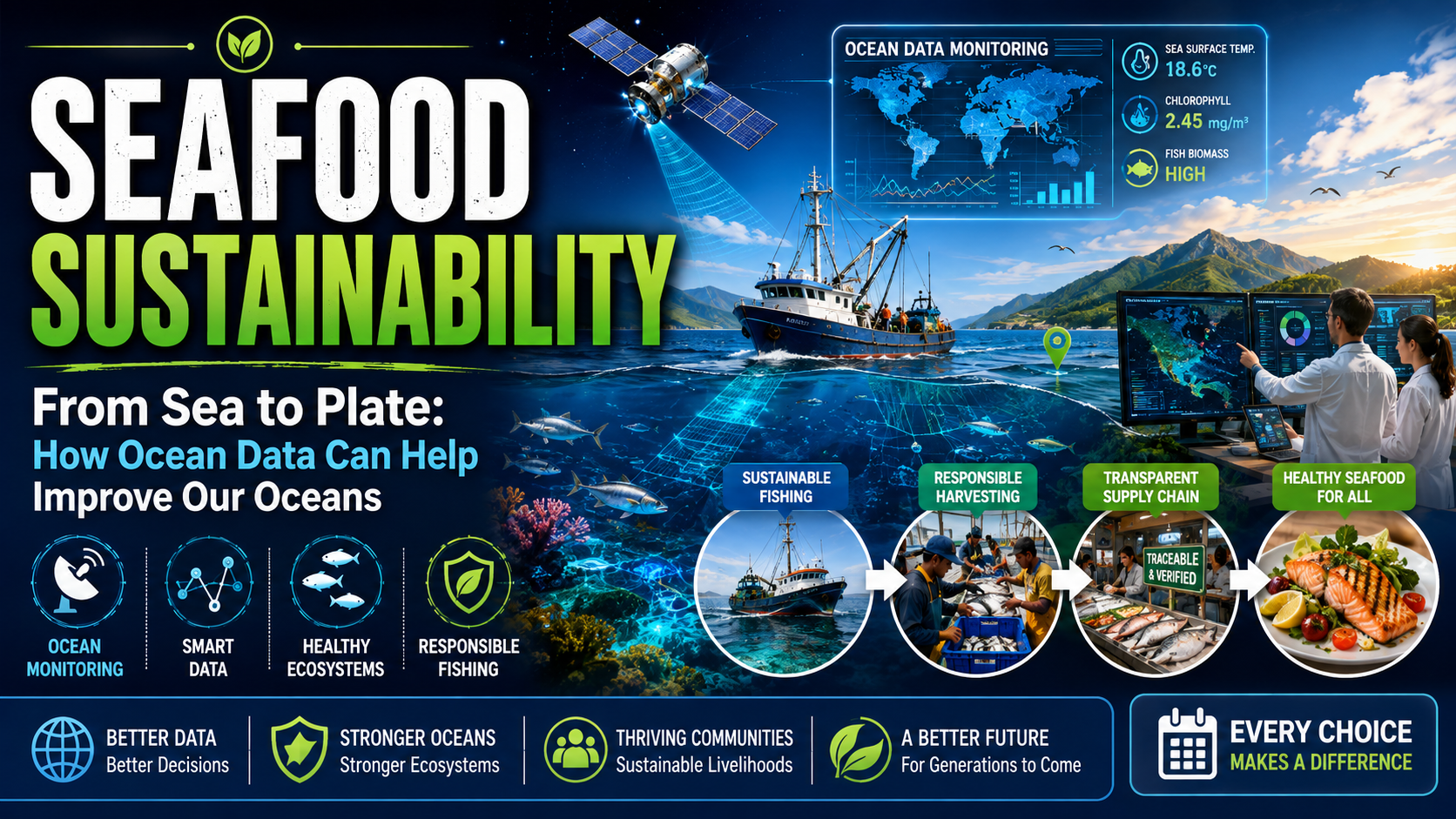
How Ocean Data Improves Seafood Sustainability Today
Introduction
Seafood connects human communities with ocean ecosystems. Millions of people depend on fish and marine products for nutrition, livelihoods, and cultural traditions, making responsible resource management essential for the future.
The difficulty is that the ocean is always changing. Fish move between feeding and spawning grounds, water temperatures shift, currents transport nutrients, storms disrupt operations, and fishing pressure varies across regions. Decisions based only on yesterday's conditions can quickly become outdated.
Ocean data helps close that information gap. Measurements from scientific surveys, satellites, buoys, vessel systems and digital catch records can reveal patterns that are difficult to see from the surface. When those records are combined with fishermen's local knowledge, they support more practical and responsive sustainable fishing practices.
What Is Seafood Sustainability?
Seafood sustainability means harvesting or producing seafood in a way that maintains healthy species populations, protects marine habitats, reduces unnecessary harm and supports the people who depend on the seafood economy. It includes wild capture fisheries, aquaculture, processing, distribution and consumer choices.
- Keeping fish populations productive over the long term
- Reducing bycatch and damage to sensitive habitats
- Using science-based fisheries management
- Supporting safe and resilient fishing communities
- Improving transparency across the seafood supply chain
- Adapting management as ocean and climate conditions change

How Ocean Data Supports Sustainable Fishing
Ocean data turns observations into evidence. A single measurement rarely provides the whole answer, but multiple datasets collected over time can reveal whether a population is stable, whether habitat conditions are shifting and whether fishing activity is concentrated in sensitive areas.
Tracking Fish Populations
Stock assessments use information from scientific surveys, commercial and recreational catches, biological sampling and other records to estimate the size and condition of a fish population. The results can help managers set catch limits, evaluate recovery plans and identify when additional protection is needed.
- Population size and age structure
- Spawning and recruitment trends
- Distribution and migration patterns
- Catch per unit of fishing effort
- Changes linked to temperature, food supply or habitat
Understanding Ocean Conditions
Fish do not respond to management boundaries; they respond to their environment. Temperature, currents, oxygen, salinity, nutrients and prey availability can all influence where marine species live and when they move. Monitoring these conditions helps researchers interpret population changes and helps fisheries adapt when familiar fishing grounds become less productive.
Ocean Data Technologies Used in Fisheries
Modern fisheries management combines several forms of ocean monitoring technology. Each system answers a different question, and the strongest decisions usually come from comparing multiple sources rather than relying on one tool.
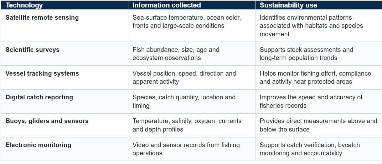
The Role of Satellites in Ocean Monitoring
Satellites can observe enormous ocean areas repeatedly, making them useful where ship based sampling would be slow or expensive. Their instruments can measure sea surface temperature, ocean color, sea level, winds and other large scale features. These observations do not usually count fish directly, but they help identify environmental conditions linked to fish habitats and movement.
Modern fisheries increasingly use satellite based observations alongside vessel data and scientific surveys. These tools can help identify environmental changes, monitor ocean conditions, and support decisions about where and when fishing activities may be most sustainable.

Real Examples of Ocean Data in Sustainable Fisheries
Around the world, fisheries increasingly use scientific data to improve resource management. Satellite observations, vessel monitoring systems, and ocean measurements help researchers understand where species are located, how conditions are changing, and where conservation efforts may be needed.
Combining technology with local fishing knowledge creates a more complete understanding of marine ecosystems. Practical applications include adjusting seasonal openings after stock surveys, using vessel positions to study fishing effort, monitoring temperature shifts that move target species, and identifying areas where bycatch or habitat damage may be reduced.
Helping Fishermen Make Better Decisions
Technology does not replace fishermen's experience. Crews understand local weather, seasonal behavior, vessel limitations and the practical realities of working at sea. Ocean data adds another layer of evidence that can make this knowledge more useful when conditions change.
For example, fishing communities can combine local knowledge with information about ocean temperature, currents, and species movement to reduce unnecessary fuel use and improve planning.
- Plan routes around changing weather and current conditions
- Avoid repeated searching in areas with unsuitable conditions
- Reduce fuel use and operating costs when data is reliable
- Stay away from sensitive habitats or temporary closures
- Share observations that improve scientific understanding
Fisheries Management Technology and Accountability
Fisheries management technology also helps authorities understand when, where and how fishing occurs. Vessel monitoring, electronic reporting and digital permits can make management faster and more transparent. These systems are most effective when rules are clear, data quality is checked and fishing communities understand how information will be used.
Data should guide decisions rather than create a false sense of certainty. Managers still need biological expertise, enforcement, social and economic context, and regular consultation with affected communities.
Improving the Sustainable Seafood Supply Chain
Seafood sustainability continues after a catch reaches the dock. Products may move through processors, wholesalers, cold storage, restaurants and retailers before reaching the consumer. Traceability information helps connect the final product with its origin and production method.
- Where and when seafood was harvested
- The vessel, farm or producer involved
- Fishing or farming methods used
- Species identification and product form
- Movement through processing and distribution
- Certification, legality and documentation records
A transparent sustainable seafood supply chain can make it easier for buyers to meet sourcing standards, reduce the risk of illegal or mislabeled products and communicate reliable information to consumers.
How Consumers Can Identify Sustainable Seafood
Consumers rarely have access to raw ocean datasets, but they can use the information produced by monitoring and traceability systems. Before buying or ordering seafood, look for clear answers to the following questions:
- Where was the seafood harvested or farmed?
- Which fishing or farming method was used?
- Is the species and origin clearly identified?
- Is credible certification or traceability information available?
- Does a science-based seafood guide provide a recommendation?
Better transparency allows consumers to make choices that support responsible ocean management. Labels and certifications are useful only when their standards, verification and chain-of-custody systems are credible, so consumers should look beyond a sustainability claim and check the supporting information.
Ocean Data and Climate Change Challenges
Warming waters, marine heatwaves, changing oxygen levels, acidification and shifting currents can alter the distribution and productivity of seafood species. A fishery that was well managed under past conditions may need new survey methods, flexible catch rules or cooperation across political boundaries as species move.
Long-term ocean records help separate short-term variability from sustained change. This gives scientists and communities more time to prepare for new fishing locations, changing seasons, habitat risks and supply-chain disruptions.
The Future of Seafood Sustainability
Future progress will depend on better integration rather than a single breakthrough. Satellite data for fisheries, marine surveys, vessel systems, digital reporting, artificial intelligence and community observations can work together to create faster and more detailed assessments.
Marine conservation technology will be most valuable when data is accessible, methods are transparent and benefits reach the communities supplying the information. Strong policies, habitat protection, responsible fishing methods and effective enforcement remain essential.
Conclusion
From sea to plate, reliable data can strengthen every stage of seafood management. It helps researchers understand populations and habitats, gives fishing communities useful environmental context, supports managers in setting responsive rules and improves transparency for seafood businesses and consumers.
Sustainable seafood requires better knowledge of marine ecosystems, and ocean data provides the evidence needed for smarter decisions by scientists, policymakers, fishermen, and consumers.
Explore more ocean science and sustainability topics at Oceanography.
Frequently Asked Questions
1. What is seafood sustainability?
Answer: Seafood sustainability means harvesting or producing seafood in ways that maintain healthy populations, protect ecosystems and support the long-term social and economic value of ocean resources.
2. How does ocean data improve seafood sustainability?
Answer: It provides evidence about fish populations, habitats, ocean conditions and fishing activity. That evidence supports catch limits, conservation measures, efficient trip planning and traceable supply chains.
3. What ocean data technologies are used in fisheries?
Answer: Common tools include scientific surveys, satellites, buoys, underwater sensors, vessel tracking systems, electronic monitoring and digital catch reporting.
4. How do satellites help track fish populations?
Answer: Satellites generally do not count fish directly. They observe environmental features such as sea-surface temperature and ocean color. Scientists combine those observations with surveys, tagging and catch records to understand fish distribution and movement.
5. Can technology prevent overfishing?
Answer: Technology can improve monitoring and evidence, but it cannot prevent overfishing by itself. Effective rules, enforcement, reliable stock assessments and cooperation with fishing communities are also required.
6. How does vessel tracking support fisheries management?
Answer: Position and movement data can show where vessels operate, help study fishing effort, support compliance checks and identify activity near restricted or sensitive areas.
7. How can consumers choose sustainable seafood?
Answer: Consumers can check species and origin information, harvesting methods, traceability records and science-based recommendations. The Monterey Bay Aquarium Seafood Watch recommendations offer consumer guidance for shopping and dining.
8. Does ocean data help fishermen?
Answer: Yes. When reliable information is combined with local knowledge, it can support route planning, reduce unnecessary searching, improve safety and help crews avoid sensitive areas.
9. What is the role of NOAA Fisheries in sustainable fisheries?
Answer: NOAA Fisheries conducts science, stock assessments and management work in the United States. Its Sustainable Fisheries resources explain how data supports fishery decisions.
10. What is the future of fisheries management technology?
Answer: The trend is toward combining satellite observations, vessel data, electronic reporting, ecosystem surveys and faster analysis. The goal is more responsive management, not replacing human expertise or community participation.
